Early Lessons Learned From Testing UAVs for Geospatial Data Collection and Participatory Mapping
BY KEVIN BARTHEL
See below to access our Concept Paper and World Bank Presentation.
UAV-based Participatory Electronic Formalization Concept Paper
Revolutionary technological advances frequently face the most resistance from the very people in the technical fields that stand the most to gain from the advance. Change generates uncertainty and fear. Fear the “machines” will supplant the practitioners. It is no surprise, therefore, to see hesitation and reluctance by surveyors and traditional aerial mapping specialists in light of the rapidly increasing use of Unmanned Aerial Vehicle (UAV) technology for geospatial data collection.
The fear is that with the UAV and the perceived largely automated process, the role of these traditional geospatial professionals will be diminished. This concern is unwarranted. As Kevin Barthel, Senior Practice Manager for Land Administration at Land Alliance stated during the 2015 World Bank’s Conference on Land and Poverty in Washington, DC; “UAVs fly themselves, take pictures themselves, but they don’t make accurate maps or title land themselves. For that we need geospatial professionals, the community and government working together”.
With the advent of the use of UAVs for geospatial data collection, the role of the technical specialist is more important, not less. In order for images the UAV captures to be useable and deliver accurate orthoimagemaps, surveyors must set the ground control points and process survey data and skills in photogrammetry and aerial mapping are essential during flight planning, post-flight image processing and orthorectification. Our early test show that essentially, the entire process minus the actual image capture requires involvement of skilled and experienced technicians.
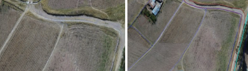
Importance of accurate ground control: Accurately measured ground control points are the foundation for the accurate georeferenced images required for our application, cadastral mapping and titling of rural land. Regulations vary from country to country as to the accuracy required for the coordinates of parcel corners. In Peru, where we are currently testing a new ‘UAV-based Participatory e-Formalization Approach’, the required level of accuracy on rural property corners is ½ meter. The UAV images can easily meet this requirement if they are based on properly placed ground control and precise measurements. However, insufficient or badly placed ground control points or one measurement blunder will negatively impact the accuracy of the georeferenced images and that of the resulting orthoimagemap. For example, the first time we tested the approach in the village of Viru in the Department of La Libertad along the northwest coast of Peru there was an error in measuring one of the eight ground control points. The inclusion of that point in the orthorectification process resulted in an approximate horizontal positional accuracy of 3.37 meters, far exceeding the expected result especially when compared to the results for a second test in the village of Quinua in southcentral Department of Ayacucho where we achieved .13 meters horizontal positional accuracy.
Importance of appropriate flight planning – and checking of the flight plan: The flight of the UAV and the acquisition of imagery may be automated but a geospatial specialist or aerial surveyor must use specialized software to prepare the computerized UAV flight plan. There are many considerations that must be accounted for when preparing the UAVs flight plan including changes in topography, spacing of the flight lines, environmental concerns, obstacles and, in the case of fixed wing UAVs, suitable take-off and landing sites. For efficient and effective image acquisition, the flight plan requires, amongst others, a calculation of the flight lines to provide sufficient endlap and sidelap (common image area on consecutive and adjacent images) on images to achieve stereoscopic coverage for the creation of a suitable digital terrain model, and at the same time avoid convergence of flight lines. While ‘automatic’ flight planning software will provide a flight plan for the UAV flight and image acquisition, it requires a knowledgeable geospatial technician with UAV flight planning and image acquisition experience to know whether the auto-generated flight plan will result in useable images – before launching the UAV.
Importance of image processing: Rapid advances in personal computer-based image and photogrammetric processing are the key technological link that unties innovative UAV imaging and participatory mapping. As Walter Volkmann of Micro Aerial Projects of Gainesville, Florida (http://www.microaerialprojects.com), a world pioneer in UAV-based geospatial data collection, reminds us “raw UAV imagery, while very useful for most qualitative analyses over rather small areas is not a map on which dimensions can be accurately measured. The affordability, diversity and deployability of UAV alone would not be nearly as advantageous in geospatial data collection if not for similar rapid advances in image and photogrammetric processing and computer vision technologies.”
The development of the ‘UAV-based Participatory e-Formalization Approach’ coincides with the emerging consensus that both best practice and timely results require geospatial data collection processes that mix technical rigor and government validation with community participation. The combination of these too often separate elements point to a necessary evolution from purely technical approach to the democratization of spatial data production[1] (Volkmann, Barnes, & Barthel, 2013). This approach goes beyond traditional ‘consultation’ with affected communities, and instead involves local people throughout the process to ensure their support and ‘buy-in’ from the collection of data to reaching consensus on the final product.
UAV technology presents an opportunity for governments and practitioners to localize interventions and work with community members as partners in the collection of geospatial data when and where needed and for multiple purposes. In our case, for forming and updating the rural property cadaster and titling land as a public good and for individual benefit.
But, the work does not stop here, sustainability is the challenge, especially in rural areas in developing economies. Building a dialogue with the community to understand the benefits and responsibilities of formal title, the internal community perceptions and empowerment, the increase in property value and the ability to protect one’s asset from outside pressure resulting from formality. All these work together to convince the community to take co-responsibility for the maintenance and sustainability of the property rights system that underpins their individual and community prosperity. Most importantly, in working together with the community the government can be more responsive to the local population cementing both social and governmental legitimacy and supporting good land governance.