How to Scale-up and Automate GIS systems for Land Tenure Documentation: Lessons from Indonesia, Myanmar, and India
By GLA and Cadasta Staff
Around the world, efforts to document land and forest rights are routinely slowed by outdated systems that rely on paper sketch maps, handwritten forms, disconnected spreadsheets, and months or even years of manual digitization processes. According to recent global estimates, up to 90% of landholdings in developing countries remain undocumented. This gap is not due to a lack of evidence of people’s rights; rather, the systems responsible for capturing it cannot keep pace with demand.
Through experience and collaboration with our alliance partners, GLA and Cadasta outline scalable, automation-driven GIS workflows designed to reduce errors, strengthen trust, and dramatically accelerate the path from field data collection to formal documentation.
A new paper presented at the 9th annual India Land and Development Conference, co-authored by Abid Hira and Leah Kellenberger of Cadasta and Kevin Barthel of the Global Land Alliance, outlines a five-pillar model tested in diverse environments across Asia. These pillars of standardized data capture, automatic cloud sync, automated quality control, automated outputs, and data interoperability serve as the backbone of a more efficient and reliable land administration system.
Across Indonesia, Myanmar, and India, three clear lessons emerged.
#1. Scaling up is a workflow problem, not a staffing problem
In Myanmar, civil society organizations and local authorities documented more than three million hectares of customary forest and smallholder parcels using standardized digital forms and a unified coordinate system. Once the data were synchronized to the cloud, automated quality control (QC) scripts flagged overlaps, missing attributes, and inconsistencies in IDs before field teams left the area.
The results were striking:
More than 30,000 tenure documents were generated via automated batch runs.
Parcel processing was five times faster than manual methods.
Large areas that previously required months of digitization and back-and-forth can now be completed and validated within hours of fieldwork.
Before automation, teams managed dozens of spreadsheets and shapefiles. These systems are prone to duplication, file corruption, and data loss. Automation and cloud storage replaced that fragmentation with a single, authoritative data flow to a single secure source. True scale comes from eliminating workflow bottlenecks, not adding more surveyors.
#2. Standardization builds trust and speeds up government approval
In Indonesia’s Central Lombok District, village officials supported a fully automated workflow to legally formalize village boundaries. Field teams in Labulia Village collected data using GPS-enabled mobile forms configured with standardized land-use lists, natural and cultural resource categories, and mandatory data validation.
Because the data aligned with national technical standards, the impact was immediate:
Boundaries across nine hamlets, spanning over a thousand hectares and 4,000+ households, were completed in three weeks of fieldwork.
Automated quality control reduced validation time from weeks to days.
Pre-formatted draft maps were generated automatically and ready for multi-agency review almost instantly.
Village and district leaders emphasized that the standardized dataset could be integrated directly into Indonesia’s official village administration system and aligned seamlessly with the national One Map Policy.
The key takeaway from this work is that governments are far more willing to adopt community-generated data when it arrives clean, consistent, and interoperable from day one.
#3. Faster, transparent processes increase community confidence
In India’s tribal belt, civil society organizations used automated workflows to support the preparation of Forest Rights Act (FRA) claims. More than 64,000 parcels across 58,000 households were mapped using mobile-based surveys. As data flowed to the cloud, automated routines identified overlaps in geometry, missing attributes, and coordinate inconsistencies.
The efficiency gains were dramatic:
Mapping time dropped from 16 days to just 2 days, a 700% increase in efficiency.
Claim maps were generated through automated templates aligned with FRA requirements.
A live dashboard enabled real-time tracking of survey progress and claim status.
A 2024 independent evaluation conducted by LandStack found:
74% of surveyors reported a major time savings.
79% of claimants said the process was easier to navigate.
70% expressed high trust in the digital outputs.
79% believed the digital evidence provided clearer and more accurate boundaries than manual methods.
Speed matters because transparency depends on it. When data moves quickly through the workflow, communities can see their parcels mapped as they walk the boundaries, watch errors flagged and corrected automatically, and trust that their submissions reflect accurate, consistent information.
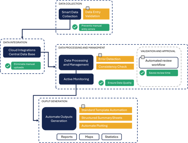
Figure 1: Automated Tenure Workflow Graphic
Why These Lessons Matter
Automation-driven GIS workflows offer governments and communities a practical path to scalable, interoperable, and resilient land governance systems that can meet national goals and support long-term stewardship.
When land documentation is accurate, fast, and trusted, families and communities can stop waiting and start investing in their homes, protecting their forests, accessing services, and shaping their futures with confidence.